Quick Links
Contacts
http://bungoma.go.ke
info@bungoma.go.ke
@@Bungoma_County_
(055) 30343, 0725571556
P.O. Box 437 - 50200
BUNGOMA
About Bungoma County
General Information
Bungoma County borders the Republic of Uganda to the West, Teso and Busia districts to the South West, Mumias to the South, Trans-Nzoia, Lugari and Kakamega to the North East.The County has an area of 3,032.2 sq. Km and lies between 1,200 and 1,800 meters above sea level and experiences mean temperatures of 23 degrees centigrade. Its latitude stands at 0.57 with the longitude of 34.56. The population of Bungoma is estimated at 1,630,934 (as projected in 2009) of which female constitute 52% while male are 48%. Age percentage distribution stands at; 0-14 years 45.9 %, 15-64 years 51.4 % and over 65 years 2.3%
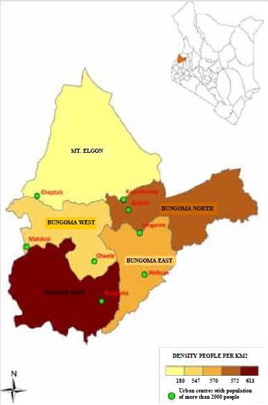
The region has a population density of 453.5 people per sq. Km with a national percentage of 3.6%. Poverty level index stand at 53% while age dependency ration is at 93.8.
Bungoma is divided into nine administrative and political divisions: Bumula, Kanduyi, Kimilili, Sirisia, Kabuchai, Webuye East, Webuye West, Tongaren, and Mt. Elgon which are further divided into 46 political wards and 88 administrative Locations.