
Quick Links
Contacts
http://garissa.go.ke
garissa@cog.go.ke, gsa.countyassembly@gmail.com
@@GarissaGov
(020)2586235
P.O. Box 57-70100, Garissa
About Garissa County
General Information
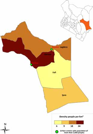
Garissa County is an administrative county in the former North Eastern Province of Kenya. Its capital town is Garissa. Garissa County has a total population of 623,060. A male population of 334,939 and a female population of 288,121 (census 2009). Garissa has six constituencies namely: Garissa Township, Ijara, Dadaab, Lagdera, Fafi and Balambala.The county is low lying, with altitudes ranging between 70m and 400m above sea level. The area is hot and dry much of the year, receiving scarce rainfall in the range of 150mm - 300mm annually. Frequent droughts and unreliable rains do not favour agriculture activities and the growth of pasture for livestock rearing. Tana River runs along the western boundary of the county and is the only permanent natural source of water for Garissa town and the surrounding areas. Seasonal Rivers (laggas) provide water during the wet season for both human and livestock, although they greatly interfere with road transportation. The county also hosts the Boni forest, a section of which is the Boni National Reserve, a protected wildlife conservation area.