
Quick Links
Contacts
http://laikipia.go.ke
info@laikipia.go.ke
@@lc_govt
254733446830
P. O. Box 487- 10400. Nanyuki.
About Laikipia County
General Information
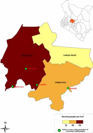
Laikipia County is one of the 14 counties within the Rift Valley region and one of the 47 counties in the Republic of Kenya. Laikipia County comprises three administrative sub-counties (the Constituencies) namely: Laikipia East, Laikipia North and Laikipia West. The Laikipia East Sub- County lie to the east, Laikipia North to the North and Laikipia West to the west of the County. The sub-County headquarters are at Nanyuki, Dol Dol and Rumuruti respectively.Laikipia County comprises four former Local Authorities namely: County council of Laikipia; Municipal council of Nanyuki; Municipal council of Nyahururu; and Town council of Rumuruti.
Laikipia County has not established structures that will define what a village is. However, the County is further sub divided into 15 divisions, 51 locations and 96 sub-locations.
Laikipia County borders Samburu County to the North, Isiolo County to the North East, Meru County to the East, Nyeri County to the South East, Nyandarua County and Nakuru County to the South West and Baringo County to the West. It lies between latitudes 0o 18` and 0o 51` North and between longitude 36o