
Quick Links
Contacts
http://makueni.go.ke
contact@makueni.go.ke
@@governorkibwana
020 2034944
P.O. Box 78-90300 Makueni
About Makueni County
General Information
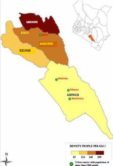
Makueni County covers an area of 8,034.7 sq km with a projected population of more than 0.9million people. It geographically borders Kajiado County to the West, Taita Taveta County to the South, Kitui County to the East and Machakos County to the North. The county lies in the arid and semi-arid zones of the Eastern region of the country. Major physical features in the county include the Volcanic Chyulu hills which lie along the South West border of the County in Kibwezi West constituency, Mbooni hills in Mbooni sub county and Kilungu hills in Kaiti subcounty. The County is divided into Six sub-counties namely:Makueni,Mbooni, Kaiti,Kibwezi East, Kibwezi West and Kilome.The county has 30 Assembly Wards namely:
- Mbooni subcounty:wards {Tulimani,Mbooni,Kithungo,Kisau/Kiteta,Kako/Waia,Kalawa,}
- Kilome subcounty:wards{Kiima Kiu/Kalanzoni,Mukaa,Kasikeu}
- Kaiti sub county:wards{Kee,Kilungu,Ilima,Ukia}
- Makueni sub county:wards{Nzaui/Kalamba,Muvau,Kathonzweni,Mavindini,Kitise/Kithuki,Wote,Mbitini}
- Kibwezi West sub county:wards{Makindu,Kikumbulyu North,Kikumbulyu South,Nguumo,Nguu/Masumba,Emali/Mulala}
- Kibwezi East subcounty:wards{Masongaleni,Mtito Andei,Thange,Ivingoni}
Our County is famous for horticulture, already there are water management community projects like dams, irrigation schemes and boreholes that boost agriculture hence bringing wealth to all. The county has a progressive authority that concentrates on service delivery and continuum investment. It has opened up development information on the web, social networks, maps as well as sms and it strides to be a model county in the country, regional and beyond.